Moab NEON (MOAB) Soil Descriptions
Distributed Soils Reports
Pedon Descriptions
Pit‐level observations and field measurements reported using the standard NRCS format. They contain volume estimates for coarse fragments > 20 mm where applicable.
Site Level Plot Summary
A narrative summary that places the sampled soil pedons in the broader context of soils and geomorphology for the entire NEON site.
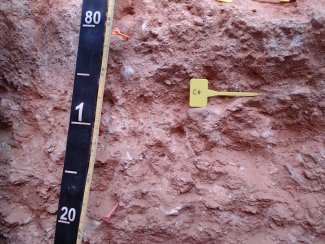
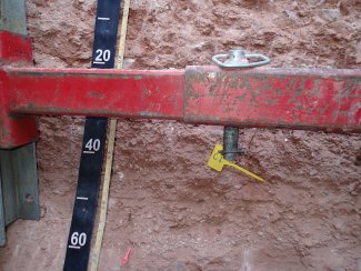
Megapit Images
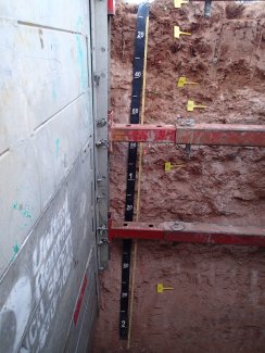
D13 MOAB megapit soil profile 0-200 cm
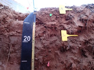
D13 MOAB megapit soil profile 0-34 cm
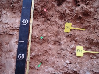
D13 MOAB megapit soil profile 25-67 cm
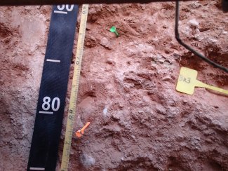
D13 MOAB megapit soil profile 59-89 cm
D13 MOAB megapit soil profile 76-121 cm
D13 MOAB megapit soil profile 108-162 cm
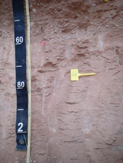
D13 MOAB megapit soil profile 145-200 cm
Megapit Pedon Description
| Print Date | Jul 22 2015 |
|---|---|
| Description Date | Feb 24 2014 |
| Describer | Keith Crossland |
| Site ID | S2014UT037001 |
| Pedon ID | S2014UT037001 |
| Lab Source ID | KSSL |
| Lab Pedon # | 14N0343 |
| Pedon Purpose | laboratory sampling site |
| Taxon Kind | family |
| Physiographic Province | Colorado Plateau |
| Geomorphic Setting | on tread of structural bench on tread of plateau |
| Upslope Shape | convex |
| Cross Slope Shape | convex |
| Particle Size Control Section | 25 to 100 cm. |
| Description origin | NASIS |
| State | Utah |
| County | San Juan |
| MLRA | 35 -- Colorado Plateau |
| Soil Survey Area | UT633 -- Canyonlands Area, Utah - Parts of Grand and San Juan Counties |
| Latitude | 38 degrees 15 minutes 5.03 seconds north |
| Longitude | 109 degrees 23 minutes 19.48 seconds west |
| Datum | WGS84 |
| UTM Zone | 12 |
| UTM Easting | 640981 meters |
| UTM Northing | 4234936 meters |
| Primary Earth Cover | Grass/herbaceous cover |
| Secondary Earth Cover | Grassland rangeland |
| Existing Vegetation | blue grama, fourwing saltbush, purple threeawn |
| Bedrock Kind | sandstone |
| Description database | KSSL |
| Diagnostic Features | calcic horizon 31 to 116 cm. |
| Slope (%) | 4.0 |
| Elevation (meters) | 1,805.0 |
| Aspect (deg) | 40 |
| MAAT (C) | 32.0 |
| MAP (mm) | 280 |
| Frost-Free Days | 130 |
| Drainage Class | well |
| Horizon Details |
A--0 to 6 centimeters (0.0 to 2.4 inches); yellowish red (5YR 5/6) very fine sandy loam, reddish brown (5YR 4/4), moist; 8 percent clay; moderate thick platy structure; noneffervescent, by HCl, 1 normal; neutral, pH 7.0, pH indicator solutions; clear smooth boundary. Lab sample # 14N01781 Bw--6 to 31 centimeters (2.4 to 12.2 inches); red (2.5YR 4/6) very fine sandy loam, yellowish red (5YR 4/6), moist; 14 percent clay; strong medium subangular blocky structure; noneffervescent, by HCl, 1 normal; neutral, pH 7.0, pH indicator solutions; gradual smooth boundary. Lab sample # 14N01782 Bk1--31 to 47 centimeters (12.2 to 18.5 inches); yellowish red (5YR 5/6) loam, yellowish red (5YR 5/8), moist; 16 percent clay; strong medium subangular blocky structure; 5 percent irregular carbonate masses in matrix; 2 percent nonflat subrounded sedimentary rock fragments; strong effervescence, by HCl, 1 normal; strongly alkaline, pH 8.6, pH indicator solutions; gradual smooth boundary. Lab sample # 14N01783 Bk2--47 to 62 centimeters (18.5 to 24.4 inches); pink (5YR 7/4) fine sandy loam, reddish yellow (5YR 7/6), moist; 13 percent clay; moderate medium subangular blocky structure; 15 percent distinct carbonate coats on bottom of rock fragments; 10 percent irregular carbonate masses in matrix; 10 percent nonflat subrounded sedimentary rock fragments; violent effervescence, by HCl, 1 normal; moderately alkaline, pH 8.4, pH indicator solutions; clear smooth boundary. Lab sample # 14N01784 Bk3--62 to 82 centimeters (24.4 to 32.3 inches); reddish yellow (5YR 6/6) sandy loam, yellowish red (5YR 5/8), moist; 13 percent clay; moderate medium subangular blocky structure; 30 percent distinct carbonate coats on bottom of rock fragments; 20 percent irregular carbonate masses in matrix; 15 percent nonflat subrounded sedimentary rock fragments; strong effervescence, by HCl, 1 normal; strongly alkaline, pH 8.6, pH indicator solutions; clear smooth boundary. Lab sample # 14N01785 Ck--82 to 116 centimeters (32.3 to 45.7 inches); reddish yellow (5YR 6/6) fine sandy loam, yellowish red (5YR 4/6), moist; 12 percent clay; structureless massive; 20 percent distinct carbonate coats on bottom of rock fragments; 10 percent irregular carbonate masses in matrix; 30 percent nonflat subrounded sedimentary rock fragments; strong effervescence, by HCl, 1 normal; moderately alkaline, pH 8.4, pH indicator solutions; clear smooth boundary. Lab sample # 14N01786 C1--116 to 160 centimeters (45.7 to 63.0 inches); reddish yellow (5YR 6/6) sandy loam, yellowish red (5YR 5/6), moist; 5 percent clay; structureless massive; carbonate, finely disseminated throughout; 40 percent nonflat subrounded sedimentary rock fragments; slight effervescence, by HCl, 1 normal; moderately alkaline, pH 8.0, pH indicator solutions; abrupt smooth boundary. Lab sample # 14N01787 C2--160 to 200 centimeters (63.0 to 78.7 inches); light red (2.5YR 6/6) very fine sandy loam, yellowish red (5YR 4/6), moist; 7 percent clay; structureless massive; carbonate, finely disseminated throughout; 0 percent unspecified fragments; strong effervescence, by HCl, 1 normal; slightly alkaline, pH 7.8, pH indicator solutions. Lab sample # 14N01788 |
Credits: This megapit soil pedon description was generously created by USDA Natural Resource Conservation Service staff, with particular thanks to Larry West, Jon Hempel, and numerous field staff.