Domain Digest No. 4: Fire, Field Sites, and Recovery
March 30, 2022
Although field sites across the Observatory are divided into 20 Domains by different ecotypes and ecoclimates, they all face extreme natural events, from flooding to hurricanes to ice storms. A prevailing extreme event over the last few decades, of course, is fire. Wildfires are growing more and more frequent, and more devastating, across the country, and NEON field sites are no stranger to the effects of these disasters.
Despite any damage done, field sites that have experienced burning provide a unique window for research on wildfire in small ecosystems, and on how a site may recover and change post-fire. A few of our field ecologists share below how their sites have been affected by fire over recent years.
Great Smoky Mountains National Park site (GRSM) and LeConte Creek (LECO) – Domain 07, Tennessee
By Margaret Cumberland - Field Ecologist II, Botanist, D07
2016 was an extremely dry year in the Southern Appalachian Mountains. There were small fires in the area for most of the fall, but the Gatlinburg Fire (designated as the Chimney Tops 2 Fire) was the worst. It occurred at the end of November, just after all our sampling had finished for the year. Our NEON tower at GRSM registered a wind speed of 87 mph before the power was cut. These high windspeeds accelerated the spread of the wildfire down the valley into the city of Gatlinburg, TN. The fire burned for about a month, covering 17,900 acres and claiming 14 lives.
The next spring, we discovered the entire GRSM tower airshed, LECO aquatic site, and six distributed plots burned at various intensities. In low intensity areas, just the leaf litter burned away, but some plots burned so hot our VST tags melted off the trees. That first year we saw lots of new seedlings, several from species that previously were only present in low numbers. Most notable were sassafras, black locust, and staghorn sumac. Due to a decrease in leaf litter, spring was extremely green with lots of herbaceous plants covering the burned ground.
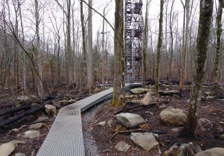
Fire damage from Tennessee Fire at GRSM
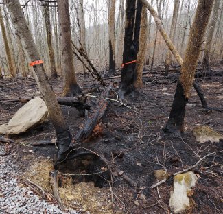
Photos of wildfire damage at GRSM.
Fast forward five years, the low-intensity burned areas now look unchanged except for the occasional scorch mark here and there. However, in moderately burned areas many trees, especially red maples, had large burn scars due to fire damage. This led to rot and fungus taking over, and the winter of 2020-2021 resulted in a large number of damaged trees crashing down. This opened up the canopy even more to the new dense stands of black locust-dominated saplings. Every new bout of collecting Vegetation Structure data adds hundreds of new saplings and small trees to our tag lists.
Melting caused by fire damage on a soil sensor array at Great Smoky Mountains field site from the 2016 wildfires.
The two plots that burned hot enough to melt aluminum have changed the most. One was a mountain laurel-dominated plot, the oils of which added to the intensity of the burn. Every tall tree was completely killed and all the shrubs burned to their roots. Now most of the mountain laurel is resprouting, but is still only about a meter tall. Fast growing trees like red maple and sweet birch are also growing up, turning the hillside into a race for dominance. However, the most dramatically different plot is one that burned hot enough to scour the bark off live trees. It used to be dominated by knee-high huckleberry, but is now choked with blackberry bushes well over six feet tall.
We are fortunate to have a little over one year's worth of data pre-fire, and a complete vegetation characterization of the tower area two years before the fire. We also have data on fire recovery on the burned plots, which can be contrasted with the effects of the un-burned, but drought affected, plots. This includes not only effects on the plant community, but also the beetle species, small mammal populations, and even aquatic chemistry record the effects the fire had on the ecological system as a whole.
Soaproot Saddle (SOAP) – Domain 17, California
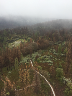
Aerial view of the trees at SOAP before a fire event.
By Jessica Bolis – Domain Manager, D17
The Creek Fire started on September 4, 2020, in the Sierra National Forest. It had burned into Soaproot Saddle by mid-month. The fire burned a total of 379,895 acres (593 square miles), making it the second largest single ignition fire to date in California. Due to the 2011-2017 drought and the subsequent Ponderosa pine mortality due to pine beetle infestation, there were significant standing and downed fuels. This was a high intensity burn over much of the site - standing trees became charcoal spires, shrubs and their root systems burned completely, the thick litter layer was incinerated, and the soil severely burned.
We regained partial access to the site in late October 2020 and were able to determine that the tower had been spared, but about half of all NEON plots at SOAP had been impacted, evenly distributed across the different plot types. Because there were still numerous hot spots, we waited until late March 2021 to conduct a thorough assessment. At that time, we found that many plots were too hazardous to enter due to standing severely burned trees and the soil in many areas was too loose to allow for routine work at others. We re-started work at SOAP in the safe areas in April 2021.
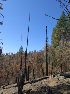
Burned trees at SOAP.
And then, another fire. On June 29, 2021, the Blue Fire started in the Soaproot Saddle site, just east of the tower. The fire was declared contained on July 8, having burned 277 acres, including about half of the previously-unburned area of the site. Again, the tower was spared, but more plots burned, including the entirety of the phenology loop. This fire also burned hot and left several plots too hazardous to visit.
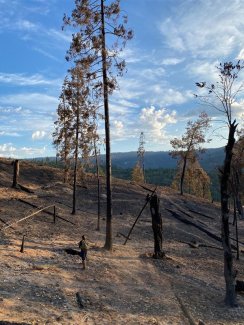
Burned trees at SOAP, D17.
NEON's airborne observations, plant diversity, and vegetation structure data at Soaproot Saddle covers all three of the most recent major transitions the site has experienced – starting out as a Ponderosa pine-dominated conifer forest, experiencing high tree mortality due to drought and pine beetle infestation, and now the post-fire recovery period. We resumed sampling in the safe areas of the site in 2021 and will continue to assess safety and soil impacts of returning to the badly burned plots at least annually.

