Monitoring Disaster Recovery From the Air with NEON
August 22, 2024
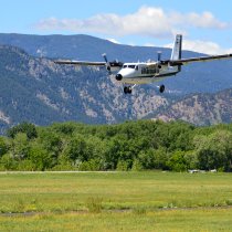
Over the last several years, we’ve seen our fair share of natural disasters at the NEON field sites. Wildfires out west. Floods in the Rockies. Hurricanes in Puerto Rico and Florida. The NEON Airborne Observation Platform (AOP) gives detailed remote sensing data at field sites both before and after a natural disaster, providing insights into impacts and recovery. The AOP is also available through NEON Research Support Services to gather remote sensing data for disaster sites outside of NEON field site locations and schedule.
Update: The Sycamore Creek, AZ aquatic site in Domain 14 burned in late August 2024, presenting another site opportunity for monitoring the effects of natural disasters. NEON recently published a Data Notification detailing the effects of this fire and impacts to the SYCA site.
Read the SYCA Site Notification
The View from Above: Remote Sensing Data for Natural Disasters
NEON conducts airborne remote sensing surveys over NEON field sites between April and October, with data collected at field sites in the continental U.S. and Alaska three out of every five years at a minimum. (Field sites in Puerto Rico and Hawaii are surveyed every five years at a minimum.) In the case of a natural disaster, the existing survey data provides a solid baseline of the “before” condition at the field site.
Remote sensing data captured by the AOP are well suited for characterizing ecosystem change from natural disasters because comparable data are collected with the same sensors at the same spatial resolution and processed with consistent, standardized algorithms. In many cases, these data are comparable to data from the location pre-event.
The data collected are high-resolution, generated from discrete and full-waveform lidar, imaging spectrometry, and high-resolution digital camera sensors. These instruments provide a detailed look at site topography, 3D vegetation structure, plant community composition, health, and productivity, among other variables. This comprehensive dataset enables researchers to analyze the ecological impacts of natural disasters and assess recovery processes. By comparing pre- and post-disaster data, scientists can gain valuable insights into the dynamics of ecosystem response and how landscape features and biodiversity are affected by such events.
Explore NEON remote sensing data
A Short History of Disasters at NEON Field Sites
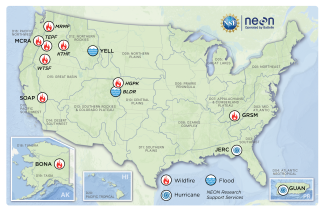
The Observatory was built for natural disaster resilience. Since 2016, we’ve documented a number of natural disasters at NEON field sites, including nine wildfires, two floods, and two hurricanes. (See the map and table below for the complete list.) Data for many of these disasters are available through the NEON Data Portal.

NEON has documented several natural disasters at NEON field sites since 2016, as shown on the map.
A few major events over the years include:
- In 2016, the Chimney Top 2 Fire in the Great Smoky Mountains caused major damage at the Great Smoky Mountains (GRSM) terrestrial site and aquatic site LeConte Creek (LECO). AOP data are available for both before and after the fires.
- Hurricane Maria hit Puerto Rico in 2017, just as our Atlantic Neotropical (D04) sites were getting up and running. While remote sensing data are not available for the time period before or immediately after the hurricane, scheduled surveys since (in 2018 and 2022) provide a picture of recovery. The experiences with Maria, which had a devastating impact across the island, helped to shape NEON’s disaster response plan.
- In 2018, the Jones Center at Ichauway (home of JERC and FLNT sites) took a direct hit from Hurricane Michael. NEON worked with the Jones Center to document the impact of the hurricane on longleaf pine forests, using lidar data from the AOP. The study was funded by an NSF grant.
- In 2020, the Creek Fire burned nearly 380,000 acres in California, including much of our Soaproot Saddle site (SOAP). The site was hit again by the Blue Fire in 2021. Remote sensing data from the AOP are available both before and after the fires, providing insight into how the landscape has transformed.

Visualized Data from the AOP shows the before and after of the 2000 Creek Fire near the NEON Soaproot Saddle site (SOAP).
| Site | Site Code | State | Disaster Type | Disaster Name | Disaster Date |
|---|---|---|---|---|---|
| Caribou-Poker Creeks Research Watershed | BONA | Alaska | Wildfire | Haystack Fires | June-July 2021 |
| McRae Creek | MCRA | Oregon | Wildfire | Lookout Fire | July 2023 |
| Great Smokey Mountains | GRSM | Tennessee | Wildfire | Chimney Tops 2 Fire | Nov 2016 |
| Soaproot Saddle | SOAP | California | Wildfire | Creek Fire, Blue Fire | Sept 2020, June 2021 |
| Jones Ecological Research Center | JERC | Florida | Hurricane | Hurricane Fiona, Hurricane Michael | Oct 2018, Sept 2022 |
| Guanica | GUAN | Puerto Rico | Hurricane | Hurricane Fiona, Hurricane Michael | Oct 2018, Sept 2022 |
| Yellowstone National Park | YELL | Montana | Flood | Yellowstone Flood | June 2022 |
NEON open data have also been used by many researchers to investigate the impacts of large-scale disturbances, including wildfires and hurricanes. Here is a sampling of some of the studies facilitated by NEON data.
Wildfires:
- A Comparison of Multitemporal Airborne Laser Scanning Data and the Fuel Characteristics Classification System for Estimating Fuel Load and Consumption
- Characterizing spatial burn severity patterns of 2016 Chimney Tops 2 fire using multi-temporal Landsat and NEON LiDAR data
- Comparison and integration of lidar and photogrammetric point clouds for mapping pre-fire forest structure
Hurricanes:
- Hurricane Michael Altered the Structure and Function of Longleaf Pine Woodlands
- Canopy density and roughness differentiate resistance of a tropical dry forest to major hurricane damage
- Vegetation structure drives forest phenological recovery after hurricane
- Effects of hurricane canopy gaps on longleaf pine and upland oak sapling growth
- The effects of a moderate severity hurricane on gap characteristics in a longleaf pine (Pinus palustris Mill.) woodland
Documenting Disasters through Research Support Services
In addition to data at the NEON sites, AOP has also captured data at some sites outside of the NEON network for PI-led research through NEON Research Support Services (NRSS). These data are openly available upon request (although they cannot be downloaded through the NEON Data Portal).
- Our first natural disaster response dates to 2012, before the Observatory was even complete. NEON collaborated with Colorado State University to document the impacts of the High Park Wildfire in Colorado. The project was funded by an NSF Rapid Grant.
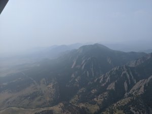
- In 2013, the AOP was called on once again to document the topographic changes caused by the Boulder, Colorado flood. The seven-day storm event, which caused severe flooding across the northern Front Range of the Rocky Mountains, happened just two months after a NEON AOP test flight. NEON surveyed the damage after the floods and created high-resolution pre- and post-flood topographic maps using lidar.
- A 2018 collaboration with BB-FLUX and the University of Colorado – Boulder, funded through an NSF Rapid Grant, used the AOP to examine critical questions about the correlations between biomass burned from wildfires and emitted trace gases and aerosols. The study looked at four wildfire-impacted areas in Oregon, Washington, and Idaho: the Teepee Fire, Watson Creek Fire, Miriam Fire, and Keithly Fire.
The NEON NRSS makes NEON infrastructure, including the AOP, available for PI-led research outside the scope of NEON’s normal data collection activities. Generally, in any given year, two of the three NEON AOP payloads are engaged in normal survey activities at NEON field sites, while the third is reserved for NRSS projects. Researchers must submit an application, and projects are completed on a cost-recoverable basis. Learn more with the NRSS FAQs.
Working with NEON AOP Data for Disaster-Related Analysis
NEON is a great resource for researchers looking at the impact of natural disasters and other types of ecosystem change. Haven’t worked with AOP data before? NEON has a handful of tutorials highlighting some of these natural disaster datasets:
- Visualize Elevation Changes Caused by the 2013 Colorado Floods using NEON LiDAR Data in R
- Wildfire Change Analysis Using AOP Reflectance and Canopy Height Data in GEE
- Detecting changes in vegetation structure following fires using discrete-return LiDAR (also recorded on NEON’s YouTube Channel)
More generally, NEON hosts educational resources, including self-paced tutorials on R, Python, and Google Earth Engine. These are available in several additional formats, such as recorded webinars.
Still not sure where to start? Use NEON’s Contact Us page, and a Staff Scientist will respond to your inquiry!

