Dive into Aquatic Ecology with NEON
February 28, 2023
Ready to dip a toe into aquatic ecology? The NEON program supports 34 aquatic field sites, including lakes, wadeable streams, and non-wadeable rivers. These sites—many of them colocated with NEON terrestrial field sites—provide a deluge of data for ecologists interested in aquatic ecology and limnology.
What's Limnology?
Limnology is the study of freshwater systems, including lakes, rivers, wetlands, and groundwater. It is a multidisciplinary field that encompasses physical, chemical, biological, and geological aspects of freshwater systems. Limnologists study a wide range of topics, including water quality, nutrient cycling, algal and aquatic plant growth, fish and invertebrate populations, and the impacts of human activities on freshwater ecosystems.
The aquatic sites in the NEON program provide a range of aquatic data products to support the study of limnology. These data products are supported by meteorological data. Want to explore the relationships between water temperature and macroinvertebrate community composition? Or how dissolved gases in surface water impact microbial communities? Or maybe you're interested in aquatic ecosystem metabolism? It's all there, waiting to be discovered in the NEON data. You can even check out physical samples from the NEON Biorepository for additional analysis.
The "Hacking Limnology" workshop held virtually last year explored how "big data" is changing aquatic ecology. Because most of the aquatic sites are colocated with terrestrial field sites, they also offer a great and unique opportunity to study how aquatic and terrestrial systems interact. There are one or more aquatic sites in every Domain except D20 (Hawaii).
Lakes, Streams, and Rivers…What's the Difference?
NEON aquatic sites include 7 lakes, 24 wadeable streams, and 3 non-wadeable rivers. What's the difference? Glad you asked:
- Lakes are classified as lentic (standing or still) bodies of water that may or may not stratify depending on meteorological and hydrologic conditions during the year.
- Streams are classified as stretches of lotic (flowing) water that are safely wadeable during most, if not all, of the year.
- Rivers are classified as stretches of flowing water that are not often, if ever, safely wadeable.
The Lakes
Lakes in the NEON program range represent a range of lentic water ecosystems, from the tundra kettle lakes to the seepage lakes of the Florida wetlands.
- Crampton Lake (CRAM), D05, Wisconsin
- Lake Barco (BARC), D03, FL
- Lake Suggs (SUGG), D03, FL
- Little Rock Lake (LIRO), D05, Wisconsin
- Prairie Lake (PRLA), D09, North Dakota
- Prairie Pothole (PRPO), D09, North Dakota
- Toolik Lake (TOOK), D18, Alaska
Prairie Lake and Prairie Pothole
The Prairie Pothole region in the Northern Great Plains is home to numerous shallow lakes formed by glacial activities. Both Prairie Lake and Prairie Pothole are small terminal wetland lakes characteristic of this region. The two sites provide a contrast based on land use. Prairie Pothole is colocated with the Woodworth (WOOD) terrestrial site on the Chase Lake National Wildlife Refuge, offering a glimpse into a relatively pristine prairie wetland. Prairie Lake is on the Dakota Coteau Field School site, which is used for both grazing and crop farming.
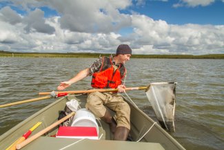
Field technician doing aquatic observational sampling at PRLA.
Lake Barco and Lake Suggs
Both of these lakes, located at the Ordway-Swisher Biological Station in Florida, are classified as seepage lakes dominated by groundwater. Lakes like this are an important part of the regional aquifer, acting as discharge and recharge systems. However, the lakes are very different in terms of pH, productivity, and biodiversity. Barco is relatively acidic and clear, with light penetrating through most of its depth. Suggs, which is also fed by surface and subsurface water flows, is murkier and supports higher productivity and biodiversity.
Toolik Lake
With a surface area of 1.48 km2 and a maximum depth of 26.2 m, Toolik is the largest lake in the NEON program. Located in the northern foothills of the Brooks Range, it is characteristic of the kettle lakes formed by glacial activity in the Alaskan tundra. It is colocated with the TOOL terrestrial site and near the Oksrukuyik Creek (OKSR) aquatic site.
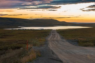
Toolik Lake at sunset
The Streams
The majority of NEON aquatic sites are classified as wadeable streams. Some of these have "river" in their names—and may be classified as rivers at other points—but are wadeable most of the time at our sampling reaches. Our wadeable stream sites include:
- Arikaree River (ARIK), D10, Colorado
- Blacktail Deer Creek (BLDE), D12, Wyoming
- Blue River (BLUE), D11, Oklahoma
- Caribou Creek (CARI), D19, Alaska
- Como Creek (COMO), D13, Colorado
- Kings Creek (KING), D06, Kansas
- LeConte Creek (LECO), D07, Tennessee
- Lewis Run (LEWI), D02, Virginia
- Lower Hop Brook (HOPB), D01, Massachusetts
- Martha Creek (MART), D16, Washington
- Mayfield Creek (MAYF), D08, Alabama
- McDiffett Creek (MCDI), D06, Kansas
- McRae Creek (MCRA), D16, Oregon
- Oksrukuyik Creek (OKSR), D18, Alaska
- Posey Creek (POSE), D02, Virginia
- Pringle Creek (PRIN), D11, Texas
- Red Butte Creek (REDB), D15, Utah
- Río Cupeyes (CUPE), D04, Puerto Rico
- Río Yahuecas (Guilarte) (GUIL), D04, Puerto Rico
- Sycamore Creek (SYCA), D14, Arizona
- Teakettle Creek (TECR), D17, California
- Upper Big Creek (BIGC), D17, California
- Walker Branch (WALK), D07, Tennessee
- West St. Louis Creek (WLOU), D13, Colorado
Arikaree River
While called a river, the Arikaree River in eastern Colorado remains wadeable along most of its 251-km (156-mile) reach. Once a major waterway, large water withdrawals for agriculture have reduced its flow substantially, and the flow rate is highly variable during the growing season. The Arikaree is also highly impacted by cattle grazing and agricultural runoff. The NEON sampling reach is on land managed by The Nature Conservancy to study the impact of cattle grazing and invasive weeds on the Plains ecosystem. Cattle have free access to the waterway at the sampling reach, which can lead to some interesting encounters.
Río Cupeyes and Río Yahuecas (Guilarte)
These two streams in Puerto Rico offer the opportunity to compare a relatively pristine neotropical ecosystem with one impacted by agriculture. Río Cupeyes, in the Maricao State Forest, runs through a wilderness area used primarily for fishing and recreation. Río Yahuecas (a tributary to Río Guilarte) is located on the site of an agricultural field station where coffee, oranges and limes are grown. They are both in rainforest areas with frequent precipitation and flooding. The Río Cupeyes sampling reach is in a lovely, unspoiled area with no roads or trails, which makes access a challenge (but well worth the trip).
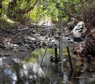
Stream sensor at the aquatic site CUPE
LeConte Creek
Nestled in the mountains at the border of Tennessee and North Carolina, LaConte Creek makes its way down the mountainside in a series of steps, pools, falls and rapids. Flowing through the Great Smokey Mountains National Park (and colocated with our terrestrial site here), the stream is largely pristine. The park is one of the most biodiverse areas in the U.S., and that extends to aquatic ecosystems, too. More than 30 species of salamanders are known to live in the area, along with bass, perch and rainbow and speckled trout. The park is also a UNESCO World Heritage Site.
The Rivers
There are only three rivers among the NEON aquatic sites, which makes each of them pretty special. Our river sites include:
- Black Warrior River (BLWA), D08, Alabama
- Flint River (FLNT), D03, Georgia
- Lower Tombigbee River (TOMB), D08, Alabama
Black Warrior and Lower Tombigbee River
Two of the NEON rivers, along with Mayfield Creek, are all part of a single watershed in the Ozarks: Mayfield Creek flows into the Black Warrior River, which then joins the Tombigbee as it flows south to the Gulf. D08 is the only Domain that offers the opportunity to study multiple connected aquatic sites. This allows researchers to study how nutrients, pollutants, and organisms move through watershed systems, providing critical insights into hydrology and biogeochemistry within the watershed. The Tombigbee River Basin drains nearly 16,000 km2 of Mississippi and Alabama.
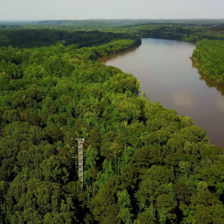
Flux tower at LENO and TOMB sites
Flint River
The Flint River is a 554-km (344-mile) river that runs through Georgia and flows into Lake Seminole at the confluence of the Chattahoochee River. The NEON field site is located near the headwaters just south of Atlanta, within the Jones Ecological Research Center. It has a watershed area of nearly 15,000 km2. The surrounding landscape at the sampling reach has been conserved as a native longleaf pine ecosystem.
Sampling Protocols at NEON Aquatic Sites
Sampling design for aquatic field sites varies a bit between the three site types. A mixture of automated instruments, field observations, and sampling are used at each site to collect physical, biological and chemical data for aquatic ecosystems.
Automated Instruments
In situ sensor stations at aquatic sites are used to collect data on physical and chemical properties of water.
- Surface water measurements include temperature, photosynthetically active radiation (PAR), turbidity, dissolved oxygen, pH, nitrate and dissolved organic matter. For wadeable streams, sensor stations are placed near either end of the sampling reach. In rivers and lakes, buoys are deployed to collect data from the deeper water, in addition to the sensor stations placed near the banks.
- Groundwater wells (up to 8 per field site, located on land near the shoreline) collect data on groundwater elevation, specific conductivity, and water temperature. They also provide easy access for sampling groundwater for laboratory analysis.
- Meteorological measurements are also collected at most sites, including temperature, relative humidity, barometric pressure, wind speed and direction and incoming radiation. Meteorological sensors may be located on towers, on buoys, or both.
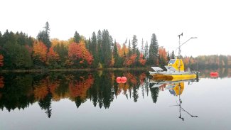
A buoy on the CRAM lake site in the fall
Biological Observational Sampling
Want to know what's living in the water? The NEON program collects data on aquatic organisms, including benthic and water column microbes, algae, aquatic plants, zooplankton, aquatic macroinvertebrates, and fish. A combination of field identification, microscopy-based taxonomic identification, and DNA sequencing is used to collect data on community composition for aquatic organisms. Field personnel also conduct an annual riparian assessment to document the dominant species of vegetation on the banks. Some organismal samples are also archived in the NEON Biorepository, where they are available to be checked out by researchers.
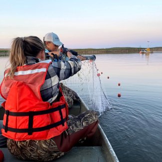
Fall fish sampling in North Dakota. NEON lake sites use three methods of catch-and-release fishing to capture a variety of species, size classes, and habitat preferences.
Non-Biological Observational Sampling
Water (including groundwater, surface water, and water column samples) and sediment samples are collected from aquatic sites for physical and chemical analysis and available in the NEON Biorepository. We also make observations on stream channel or lake morphology, discharge rates for streams and rivers, riparian phenology, and more.
Interested in learning more about these methods? All of NEON's aquatic protocols can be found in the Data Portal Document Library. See the full list of aquatic data products in the Data Portal.

