Case Study
Monitoring Biodiversity on a Global Scale
December 20, 2023
Remote sensing data is a viable way to predict biodiversity over large areas based on forest structure maps. A recent paper in Environmental Research: Ecology, Inferring alpha, beta and gamma plant diversity across biomes with GEDI spaceborne data, explores the potential for using air- and spaceborne lidar to monitor biodiversity on a global scale. The study, led by Dr. Chris Hakkenberg of Northern Arizona University, used NEON airborne laser scanning (ALS) data with NASA's Global Ecosystem Dynamics Investigation (GEDI) spaceborne lidar to validate a unique approach that uses "characteristic" forest structure to infer biodiversity for areas difficult to directly sample.
Inferring Biodiversity from Remote Sensing Data
Biodiversity is a critical dimension of ecosystem health and resilience. "The number of studies on global biodiversity monitoring still lags behind those related to carbon and climate change," says Hakkenberg. "However, we are facing a global biodiversity crisis and habitat loss has been increasing at a concerning pace. We urgently need to develop better ways to map and monitor biodiversity changes, not just locally but on a regional and global scale."
Biodiversity studies based on field observations can provide insights into how ecosystems are changing at a local level. However, observational studies are labor-intensive, time-consuming, and generally only feasible over small scales. To understand biodiversity across large regions or continents, different methods are needed.
That's where lidar data comes in. Lidar (for Light Detection and Ranging) is a remote sensing technology that uses pulsed lasers to generate precise, three-dimensional information about surface characteristics of a landscape, including topography and vegetation structure. The NEON Airborne Observation Platform (AOP) is equipped with lidar systems on low- and slow-flying aircraft that generate detailed data about the 3D forest structure at NEON terrestrial field sites. Spaceborne lidar systems like NASA's GEDI system can provide forest structure data for large swaths of the globe, albeit not continuously like airborne lidar, and at a coarser resolution.
The relationship between forest structure and plant biodiversity, or Biodiversity Structure Relationships (BSRs), has seen increasing attention among the science community. BSRs have been studied for a variety of taxa, including trees, birds, and small mammals. In general, more diverse and varied vegetation structure is correlated with higher biodiversity across both plant and animal species. Thus, maps made from lidar data can be used to infer biodiversity for a plot or a region, even without direct field observations.
Hakkenberg explains, "With current technologies, we are not able to directly measure biodiversity at large scales. But we can directly measure forest structure, by which I mean the three-dimensional arrangement of vegetation in a forest canopy. So, if we can map forest structure, and it has a relationship with the variable that we're really interested in, then we can use it as a proxy to map ecosystem attributes that aren't directly observable, including habitat, carbon sequestration or wildfire potential. In this case, we are looking at using spaceborne lidar data to map biodiversity over large extents."
From NEON to GEDI: Connecting Airborne and Spaceborne Lidar Data
This study aimed to determine whether forest structure data from NASA's GEDI lidar system can be used to infer biodiversity across larger regions, including areas not directly sampled by GEDI. GEDI, which is mounted on the International Space Station (ISS), covers latitudes between 51.6° N and 51.6° S, a spread encompassing most of Earth's forests including those in the tropical and temperate regions.
However, GEDI data is not continuous. GEDI takes "snapshots" of forest structure that are roughly 25-meter circular samples. These snapshots are not contiguous and may possess as much as 10 meters of uncertainty in any direction in their exact location. This imprecision can matter quite a bit, especially if there is a high degree of variability in vegetation on the ground.
To correlate GEDI data with on-the-ground observations, Hakkenberg needed to more precisely geolocate the GEDI footprints. He says, "If you're off by ten meters, you could be in an entirely different ecosystem type. So instead of a snapshot of the forest you are interested in, you may be looking at data from a patch of grassland ten meters west."
Here enters the NEON lidar system. Using lidar data from the AOP, Hakkenberg and his coauthors were able to increase geolocational precision from GEDI footprints taken at NEON field sites from 10m to just 1-2m. By comparing NEON and GEDI data to find the best possible match, they determined where the GEDI footprint landed within the NEON field site with a high degree of precision. This "bullseye method" was originally developed by Dr. Stephen Hancock at the University of Edinburgh.
This precision enabled them to make an apples-to-apples comparison between NEON and GEDI data to see how they predicted diversity at a given NEON field plot, even if GEDI didn't directly sample from that location. The analysis showed that while NEON data provide a higher degree of detail on structure, GEDI's spaceborne data perform almost as well for predicting biodiversity, and can be applied at near-global scales.
Taking the analysis a step further, they aggregated structural information from dozens to hundreds of GEDI footprints to develop a generalized picture of the "characteristic forest structure" surrounding each NEON plot. This characteristic forest structure describes the range of structures in the area, including average tree heights as well as variance in the vertical profiles of stems, branches, and leaves. Hakkenberg explains, "There is very little chance that an individual GEDI footprint is going to exactly coincide with a plot where biodiversity is measured in the field, such as a NEON plot. So, the conceptual leap in this paper that we were testing is: can we take many GEDI shots that are near a plot and infer the general forest structural profile (or a "characteristic forest structure") for the forest surrounding that plot, even if we can't measure it directly? And if we do that, how well does characteristic structure from GEDI do at predicting plant and tree diversity at a specific plot?"

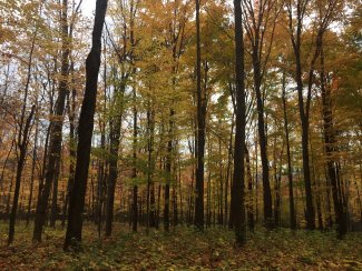
Forest at TREE in fall
Their analysis showed that predictions made using aggregated GEDI data are similar to predictions made with more fine-grained NEON data. "NEON lidar data is really important for mapping fine-scale changes in the landscape," Hakkenberg says. "But our study showed that aggregated GEDI data is almost as good at predicting plot diversity, as well other biodiversity indices like species turnover across NEON sites, and regional diversity patterns among NEON sites. These results support the potential to apply BSRs for larger-scale applications if we want to measure or monitor biodiversity across taxa and at large extents."
Monitoring Ecosystem Health on a Global Scale
"GEDI is already collecting forest structure data near-globally," Hakkenberg notes. "Our study shows that it can also be used to map biodiversity across the globe in a way that's completely consistent and does not add any cost."
Spaceborne lidar has the potential to provide a broad look at changing ecosystems, especially in areas that are currently understudied. A better understanding of where and how forest structure is changing is critical for global policy, planning, and conservation efforts. For example, global remote sensing data is being used to identify habitat preferences for endangered species such as forest elephants and gorillas, and used to prioritize habitat conservation efforts. This aggregated GEDI data approach could also potentially be used to study and monitor changes in other aspects of ecosystem function and health, such as carbon flux. In fact, GEDI's primary mission is to use estimates of forest structure to measure global carbon stocks and monitor changes in carbon sequestration in different regions over time. Hakkenberg's next study will examine relationships between forest structure data and wildfire severity, risk, and vulnerability.
As ecosystems continue to adapt to climate change and other anthropogenic pressures, widescale monitoring of biodiversity and other elements of ecosystem health and function will be invaluable. This study shows that spaceborne remote sensing data, while less precise than airborne lidar, have the potential to greatly enhance our understanding of our changing planet.

